
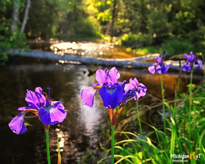
Shalda Creek Iris by Michigan Nut Photography
John got this shot of wild Iris along the banks of Shalda Creek in the Sleeping Bear Dunes National Lakeshore.
See more on the Michigan Nut Facebook page and at michigannutphotography.com.

Shalda Creek Iris by Michigan Nut Photography
John got this shot of wild Iris along the banks of Shalda Creek in the Sleeping Bear Dunes National Lakeshore.
See more on the Michigan Nut Facebook page and at michigannutphotography.com.

The Karen Andrie and Endeavor by Craig Hensley
Craig got this tasty shot of the tugboat Karen Andrie and the barge Endeavor making their way up the Detroit River last summer. Detroit is on the left & Windsor, Canada is on the right.
Head over to Craig’s Flickr and his website for more!

Flowing all night long by Mark Smith
While this dam isn’t an actual waterfall, I’m going to overlook it due to seasonal appropriateness. In their excellent overview of the history of Fishtown in Leland, the Glen Arbor Sun shares:
Fishtown is located where there once was a natural fish ladder on these traditional Native American fishing grounds. It is one of only few commercial fishing villages still operating today in Michigan. The Native Americans called this spot Mishi-me-go-bing, or alternatively Che-ma-go-bing or Chi-mak-a-ping, meaning “the place where canoes run up into the river to land, because they have no harbor.”
French Canadian millwright, Antoine Manseau, along with his family, are thought to be among some of the first whites to settle here. They came from North Manitou Island in 1853. The following year Manseau and his family, along with John Miller, built the dam at Fishtown. It raised the water level in the river and in Lake Leelanau by as much as an astonishing 12 feet. Since the dam prevented boat traffic from going back and forth in their daily business, launches were, and still are provided on both sides of the dam.
Lots more in the Sun. You can learn more about the history of the dam from Fishtown Preservation.
Mark took this photo a week ago. See more in his Leland gallery & view and purchase his work at Leelanau Landscapes.

Misty Bond Falls by Yanbing Shi
The GoWaterfalling entry for Bond Falls near Paulding in the Upper Peninsula, says (in part):
Bond Falls is in the western U.P. on Bond Falls Rd, east of Pauding MI. This is the most impressive waterfall in Michigan with the possible exception of Tahquamenon Falls. The main drop is 40 feet high and 100+ feet wide. Above the main falls are a series of cascades and rapids that must drop a total of 20 feet.
The water level is controlled by a dam, and a steady flow over the falls is maintained for scenic reasons. Of course during the spring melt the flow is much higher.
Bond Fall is a Michigan State Scenic Site. The site was renovated around 2003. The old parking area was upstream of the falls, and a steep concrete stairway led to the base of the falls. The new parking area is near the base of the falls, and a level boardwalk leads you to prime views of the falls. The area is not quite as wild looking as it once was, but it is accessible to everyone. The trail on the east side of the falls is still wild with some steep rocky climbs. There are other trails that go off into the woods, and there are campsites nearby.
In addition to being very picturesque, this is a very popular waterfall, and unless you visit early in the morning or in winter, you are going to have a lot of company.
Bringing back this November 2014 photo I featured of Bond Falls for another look! See more in Yanbing Shi’s Landscape gallery on Flickr.

Travel the Mitten has a great entry on Kakabika Falls that says (in part):
The Ottawa National Forest covers more than 990,000 acres of Michigan’s Upper Peninsula and is a popular spot for outdoor recreation, camping, and wildlife viewing. The forest is also home to many waterfalls including Kakabika Falls, a set of cascades on the Cisco Branch of the Ontonagon River. These falls can be reached by a short drive north of the Watersmeet/Marenisco area, and a short, easy hike into the woods. The setting here is peaceful and there is a good chance you won’t encounter other travelers when you visit.
The tallest drop of Kakabika Falls is maybe 8 to 10 feet (most of the drops range from 1 to 5 feet), but this waterfall is more about the sum of its multiple drops than one large drop. The river makes a series of S turns here, and the trail closely parallels the river providing many great vantage points of each drop. As is the case with most waterfalls of this size, it is always best to visit in the spring or after decent rainfall. In dry summer months, we have found that there was barely any water flow here.
Click through for more including photos, map & directions from a really excellent website for Michigan travel ideas!
Neil shared that this is one of the many magical places in the Michigan’s Upper Peninsula, something that one look at his Instagram is all you need to see the truth in that! You can also follow Neil Weaver Photography on Facebook and view & purchase prints (including this one) on his website.
Many (many) more Michigan waterfalls on Michigan in Pictures!

Sturgeon River Gorge I by David Mayer
This week longtime Congressman Dale Kildee passed away. Kildee, uncle of current Flint Representative Dan Kildee, represented Flint for over 30 years earning the nickname “the Cal Ripken of Congress.” He was involved in many efforts including some vital early childhood bills and (of course) auto industry support, but one interesting thing that I learned from writer David Dempsey is that Dale was the sponsor of the 1987 Michigan Wilderness Act which created 10 State Wilderness Areas protecting nearly 100,000 acres of old growth forest, dunes, lakes, and rivers including Sturgeon River Gorge.
Thank you Dale for your work on the behalf of Michigan’s wild places! Click for a map of all 18 of Michigan’s Wilderness Areas.
David took this back in October of 2012 in the Sturgeon River Gorge Wilderness. See more in his Porcupine Mountains gallery on Flickr.

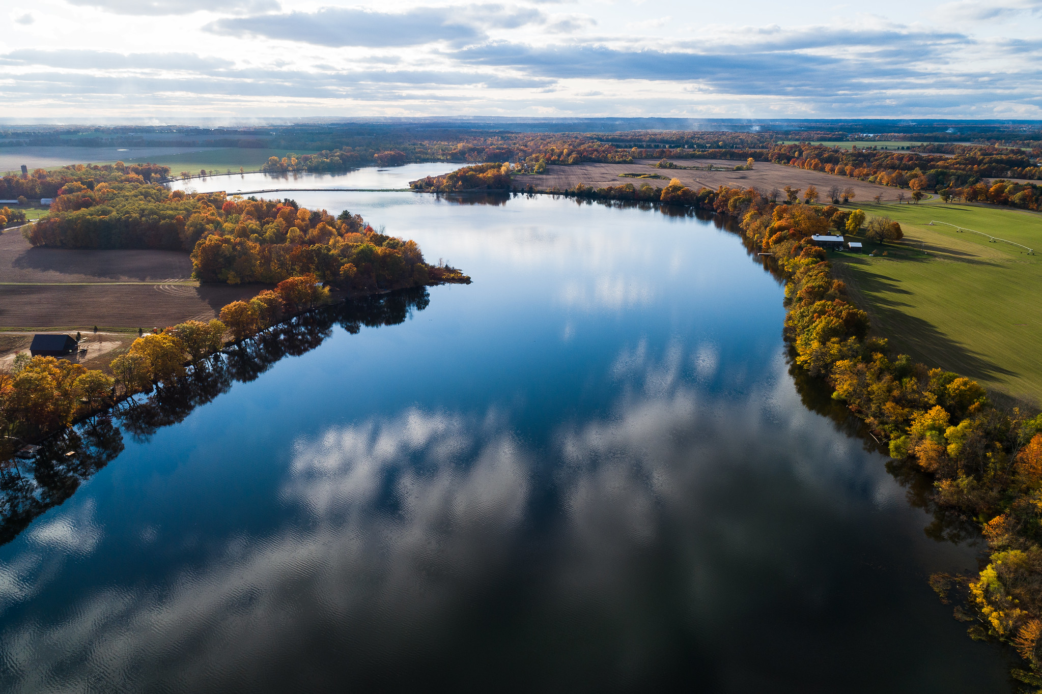
Riverbank Reflection by Jeff Dehmel
Sweet shot by Jeff from last October. See more in his Fall 2020 gallery on Flickr.
More fall color on Michigan in Pictures!

The House at the End of the Dock by Mark Smith
I can’t be the only person who wishes I lived in the Hall Cottage in Leland’s Fishtown!
See more from Mark at Downstreamer on Flickr!
Encyclopedia Britannica says that the 210-mile-long Saint Joseph River rises near Hillsdale in south-central Michigan, flowing generally west with a swing south into northern Indiana through Elkhart and South Bend before reentering Michigan to empty into Lake Michigan at Saint Joseph and Benton Harbor. Check out places to access the St. Joseph on Michigan Water Trails.
Bill took this photo of the St Joseph River near the Langley Covered Bridge with his drone a couple of weeks ago. See more of the river & the bridge in his Michigan: St. Joseph County gallery on Flickr!
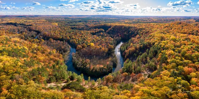
High Rollaways Horseshoe by Alanna St. Laurent
Traverse City MI explains the name for the High Rollaway, officially the Manistee River High Banks Rollaway:
The high river bluff is the reason for the area’s unusual name. At the turn of the last century, lumbermen needed inexpensive ways to transport timber from the forest to the sawmills and wide-flowing rivers like the Manistee were the answer. Steep banks were used to “rollaway” the logs in a thunderous avalanche to the water where they floated to the mills. Unfortunately, the practice quickly stripped the vegetation from the river banks and, by the time the lumbermen moved on, eroding sand was clogging and narrowing the rivers. In the last 20 years, efforts have been made to stabilize the Manistee River High Banks with fieldstone terraces and replantings. The observation platform was installed in 2001 so visitors could enjoy the stunning view without damaging the fragile system.
Alanna took this stunning photo with her drone last week. Follow her on Facebook for lots more great shots & check out her photography workshops at Creative Visions Photographic Workshops!
